
2012 Native Azalea Tours | Azalea Society of America
ARS+ASA Joint Convention • APPALACHIAN SPRING 2012 • Asheville NC • May 4-7, 2012
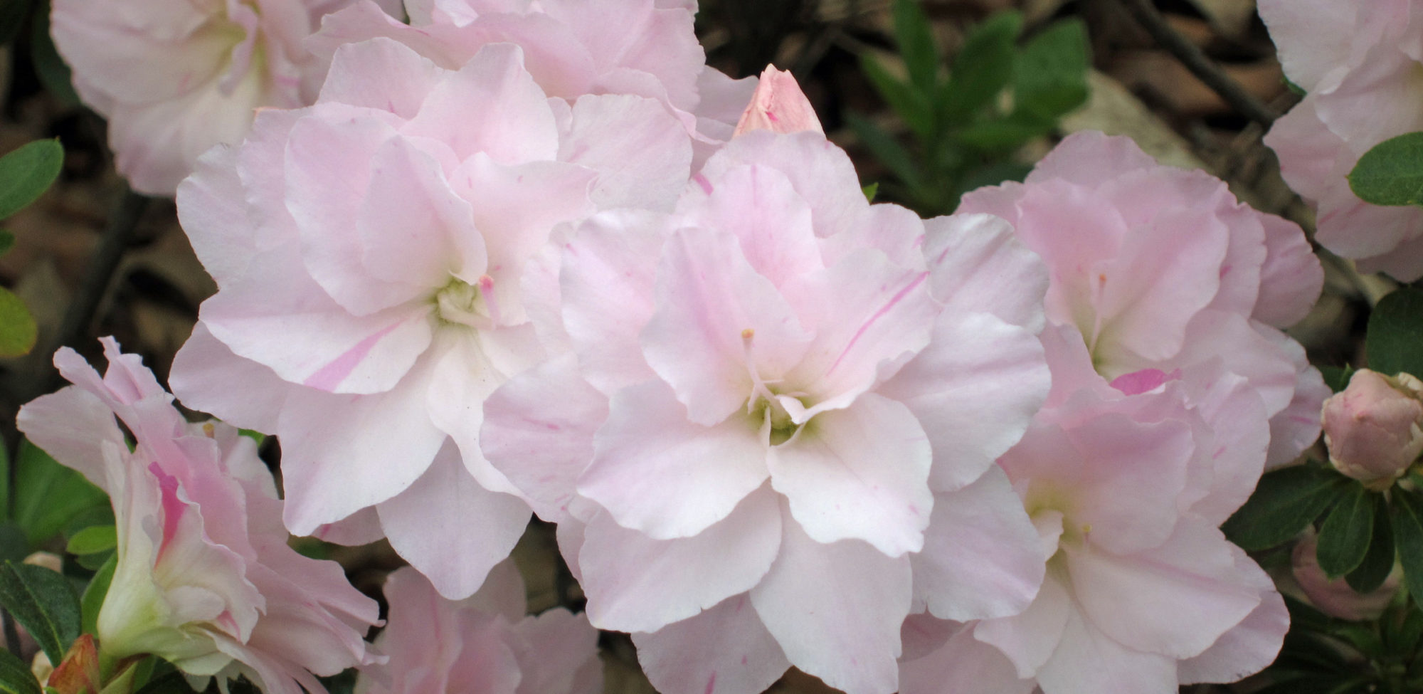
Although it is too early for some of the native azalea and rhododendron species to be in bloom, R. vaseyi and R. minus var. carolinianum should be in bloom on the Blue Ridge Parkway in early May—at least they were on May 1, 2002 at milepost 416.9 near the Looking Glass overlook, 4492′ elevation, as shown in the picture (click it and other thumbnail pictures for bigger pictures). And there may also be a few early R. calendulaceum showing as well. While there are some R. vaseyi near Grandfather Mountain to the north of Asheville, R. vaseyi are much more abundant along the Parkway to the south of Asheville. There are many sites about the Blue Ridge Parkway on the web, including a picture travelogue covering an area mostly south of Asheville. You can download this page for printing.
Don Hyatt has written an article for the Journal ARS called Chasing the Bloom about the botanical delights to be found traveling to or from Asheville, with a particular focus on the Blue Ridge Parkway. Consider downloading it, printing it, and taking it with you on either of the Blue Ridge Parkway trips described here, as it adds a lot of detail to these brief descriptions. with pictures and milepost locations of the flowers. Besides the numerous overlook areas, you can park anywhere along the Parkway (except within the few designated watersheds) as long as all wheels are off the pavement—here, Don Hyatt has parked near milepost 425 to admire a wall of R. vaseyi (points along the Parkway are located by their “mileposts”: small stone markers on the right side of the road driving southwesterly which show the number of miles from the start of the Parkway in Virginia). The distances and times shown below, e.g. “(7.5 miles in 15 minutes)” are for the miles you can expect to drive and the time spent in your vehicle. They do not include any miles hiked or time spent hiking or stopping along the way to admire the views and the plants.
Blue Ridge Parkway/NC 215 (95 miles in 3 hours)
This tour is the easiest way to see R. vaseyi in the wild, since it is all on paved roads with azaleas along the roadsides. To get to the Blue Ridge Parkway to the south from the Crowne Plaza hotel (7.5 miles in 15 minutes), leave the Crowne Plaza on Resort Dr, merge onto I-26 E, go 5 miles to exit 33 to US 191 S, then 2.5 miles to the Blue Ridge Parkway entrance at milepost 393, just past the North Carolina Arboretum entrance, and turn to the right onto the Parkway. Head south on the Parkway starting at the entrance near the North Carolina Arboretum at milepost 393, continue past the Pisgah Inn (good food, beautiful vistas, no reservations needed) at mp 410 to a left turn onto NC 215 at mp 423, and continue on NC 215 for about 3 miles to Charlies Creek Road. The end of the ridge at that point is the end of the azaleas. With a very short hard climb there you can walk among the azaleas along the ridge.
Either turn around there and backtrack to the hotel (total trip about 80 miles) and see more azaleas along the Blue Ridge Parkway, or continue 14 winding miles on NC 215 to a left turn onto US 64, go 10 miles to and through Brevard NC to merge with NC 280 E, 16 miles to a left turn onto I-26 W, 12 miles to left exit 3A onto US 19/23, 0.5 miles to a right turn onto Regent Park Blvd (becomes Clayton Ave), 0.5 miles to the Crowne Plaza hotel.
Pilot Mountain/215/Blue Ridge Parkway (90 miles in 3 hours 30 minutes)
Wayah Bald (85 miles in 2 hours)—usually not in bloom until late May
From the Crowne Plaza hotel, merge onto I-26 E, take exit 31B onto I-40 W. Go 18 miles to exit 27 onto US 19/23 to Waynesville. Go 27 miles and exit onto US 23 south to Dillsboro. Go 24 miles, going past Franklin. Turn right onto Old Murphy Road, and take an immediate left onto Wayah Road. Continue a little over 9 miles on Wayah Road to the base of Wayah Bald, turn right onto a gravel road and go about 4 miles to the top, admiring the R. calendulaceum and wildflowers along the way. A short gentle paved trail goes to an observation tower and an impressive stand of R. arborescens. Walking a short way along the Appalachian Trail to the left (north) you will see more R. arborescens.
To continue on to Copper Bald (23 miles in 1 hour and 45 minutes)—usually not in bloom until late May: return 4 miles to Wayah Road, turn right and continue 1.5 miles on Wayah Road past the Wayah Bald turnoff, turn right onto FS 711 and go about 15 miles to the end, go right on Cold Creek Road 0.5 miles, then right on Bens Creek Road for 2 miles to the end at Burningtown Gap, about 3 miles north of Wayah Bald on the Appalachian Trail. This spot, roughly halfway between Wayah Bald and Copper Bald, is one of the trail heads the FBI used when they were looking for Eric Rudolph.
To see the Copper Bald azaleas, turn left (north) on the Appalachian Trail. It goes up rather steeply for a half mile or so and then levels out and becomes a more gentle slope. While there are wildflowers all along the trail, there are no azaleas for about half to three quarters of a mile. R. calendulaceum appears first, on both sides of the trail. There is a particularly nice group of R. cumberlandense on the left edge of the trail. A little more than a mile (or an hour) from the trail head is a shelter with a potable spring. Next (10-15 minutes) is a sign showing that you are 1.4 miles from the trail head. Soon thereafter, you will begin seeing R. arborescens and various natural hybrids of R. arborescens, many of them shades of pink, near the right (uphill) side of the trail, with others still further off the trail on the uphill side. Some are marked with plastic tape and/or aluminum tags. Photographs, cuttings and seed have been collected from these tagged plants over the past few years. If you continue much further on, the trail begins to go downhill, and you are past the explored stands of azaleas.
While there are also some very nice azaleas to the left (downhill) off the Appalachian Trail, beware! It is easy to get lost when you go downhill off the trail—two folks have been lost, one overnight, by going off the trail down the hill. A map shows the trail makes a very sharp turn to the right about half way up to Copper Bald, and in each case, the lost person went off-trail before that turn.
Southern Highlands Reserve (total drive 110 miles in 3 hours)
Southern Highlands ReserveA 55 mile trip from the hotel to the top of Toxaway Mountain takes you to the Southern Highlands Reserve, a privately funded nonprofit organization which manages a 130-acre property at elevations up to 4700 feet, with possibly the largest display of R. vaseyi in the wild, along with many other Appalachian Mountains native wildflowers and other plants.The Southern Highlands Reserve is dedicated to the cultivation, preservation, and display of plants native to the Southern Appalachian Highlands. The garden is divided into two distinct areas. In the Core Park, where plants are displayed according to their visual appeal, native plants and their cultivars are mixed. In the natural areas, where plants are placed in their natural communities, only native plants are used. The garden design is a combination of professional input combined with liberal use of native stone and local talent to achieve a must see, once in a lifetime event.
There is more to see and enjoy than time and energy will allow in a one-day visit. Features of the Reserve include:
• the Woodland Glade featuring native groundcovers;
• the Wildflower Labyrinth, a centuries old seven ring design featuring Coreopsis and Butterfly Weed in early May;
• the Azalea Walk, featuring Gregory Bald seedlings;
• the Vaseyi Trail, a magic walk through Galax beds under a canopy of R. vaseyi;
• the Vaseyi Pond, a world unto itself;
• the Viewsite and Firepit with a view limited only by weather and your imagination; and
• many more walking possibilities.If that isn’t enough, a short hike toward the mountaintop leads to what may be the largest colony of R. vaseyi in the world.
Rhododendron vaseyiAll visitors must be accompanied by an employee of the Southern Highlands Reserve, and a significant donation is suggested to cover their time, so a group of not more than 25 persons is recommended. Expect to spend at least 2 to 3 hours.
Rhododendron vaseyiSince they can only accommodate one group per day, make a reservation for your group in advance by emailing John Turner, Executive Director, or by filling out and sending their Contact form. Currently available days near the 2012 Convention are Thursday and Friday May 2-3, 2012 and Wednesday May 8, 2012. Driving Directions From Asheville, take I-26 toward Hendersonville. Take the airport exit and go right at the end of the ramp. You will immediately pass the airport on your right. You will be on Hwy 280 (Airport Rd.). Follow 280 to Brevard, NC. In Brevard, 280 becomes Hwy 64 right past Wal-Mart. Follow 64 through Brevard to Lake Toxaway, 18 miles. Now …. follow the directions below.
Coming from the east from Brevard on Hwy 64 look for the Bill McNeely, Jr. bridge that spans the Toxaway river at the dam. Go about 1 mile and look for the entrance to Lake Toxaway Estates on your right.
From Highway 64 turn into Lake Toxaway Estates at the sign that reads “Lake Toxaway Country Club and Greystone Inn” and slow down at the guard gate. If the guard is present, please inform him that your destination is the Southern Highlands Reserve on Summit Ridge Road. Otherwise, you may simply drive past the guard gate. You are now on West Club Drive.
Approximately 2.1 miles past the guard gate, the road forks at a stop sign, go straight ahead onto Chestnut Trace. This will be up a steep grade. There will be a sign indicating your fork leads to the Country Club and the Greystone Inn. This road has extreme changes in elevation and hairpin curves—be careful.
When the road ends, you will turn left onto Fairway Drive and proceed 0.1 mile past a small pond and bear left at the fork in the road. The sign indicates you are beginning your climb of Toxaway Mountain which will last approximately 2 miles. You will encounter a few side roads along the way—be sure to stay on Toxaway Drive. At the first fork, bear right. From that point on, you should choose to bear left (uphill).
Near the top of the mountain, the road will level off and descend slightly after a sharp turn to the right. You will take the next left turn onto Summit Ridge Road. Follow the road 0.5 miles through the rock pillars and all the curves until the road levels off once again at the top of the mountain. Shortly before the top, the road will veer to the right. The brown gravel drive to the right, marked 558 on the mailbox post, will take you to the office and parking.
John Turner cell – 828-226-0312